
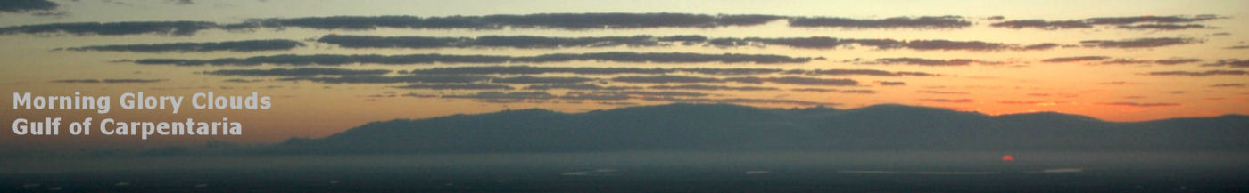

Morning Glory Pilot Notes
In 1991 Rob Thompson & I experienced very strong lift sometimes for 60 km or more, between 2000 to 2500 feet. The polar curve of the G109 gives a sink rate of 6 m/s at 110 knots, at which speed we were still rising at 4 knots (2 m/s), so the lift was 8 m/s. This was the strongest lift so far encountered, and I think we saw this two days in a row. However, when it is very strong, the band is very narrow, 200 to 300 metres, perhaps less. Certainly we found ourselves at times very close to the cloud indeed.
Morning Glories with this strength are quite distinctive, having a vertical
wall of cloud several thousand feet high, and often a stream of very low
fog-like stretching out in front for some kilometres from the base of the
cloud. The lift tends to level out to about 2 to 4 knots at around 5 to
6 thousand feet. At this altitude the band can be very wide, varying from
400 metres in weak areas to 5 km or more, extending well out in front of
the leading edge. On subsequent flights I have experienced lift in excess
of 15 kts for stretches of 50km or more, and over 8 kts for 2- 300 km.
Clouds of this strength are rare, and are usually at their best over the
Gulf between Point Parker (abeam Mornington Island) and Groote Eylandt
on the western side. In 1994 I soared one from Burketown to Groote and
then back to Borroloola, not much under 700km in about four and a half
hours. A pretty good run for a comparatively sluggish G109.
Rob Thompson & Russell White
Grob G109 motorglider
That cloud had well formed lenticulars at around 8-9000 feet, and cumuliform tops from the secondary going to well over 12,000'.
An upper system of stratus-like cumulus lines which often accompany the Morning Glory vary considerably in height. We soared to a tad over 9 thousand on one occasion on a fairly modest cloud, climbing steadily in 2 knots from 5 thousand way out in front of the cloud just before the system died, and were not very far below the base of the upper stratus which Rob & I estimated at about 11,000 ft (perhaps 12). At other times, however, the small lenticulars which sometimes form have been much higher, and I think that 20,000 plus would be a good estimate on some days for the high stratus.
The waves travel at speeds up to about 35 knots, averaging around 25 (slowing considerably as the system dies). Most of the strong roll-clouds have very low bases, often 400-500 ft or lower. Weaker clouds have higher bases. Tops vary from 2000 to 6000 feet, with the rare monster waves going much higher. Lift begins very close to the ground as a rule, often as low as 400ft as far as 2km in front of the leading edge.. The lift band is frequently extremely broad, anything up to 10 kilometres at altitude, but is sometimes very narrow and fierce (and terrific fun). Lift is not necessarily proportional to size or shape, but bigger is usually better.
Sometimes there will be a great kink in the system, where one section finishes and the next starts perhaps several kilometres further to the NW. There is often a great mass of dead or sinking air between the two. It is possible to cross back to the secondary (which will sometimes be working better than the primary), and search from there for a route to the next section. There are no hard and fast rules as there are a great many variables to each cloud. Rarely is one like another. One thing to watch in these intersections, as noted in the 1995 AOPA & AG articles, is the terrific turbulence which may occur at low altitudes. In '94 I went for an exploratory motor under one of these, expecting good lift as I traversed across to the second section which had much better form, and struck moderate to severe rotor. I came out with my feathers quite ruffled.
Satellite pictures indicate roll-clouds far in excess of 1000 km. From Kangaroo Point to Borroloola is 400 km, and this is quite easy in a fast glider, conditions permitting. From there, Ngukurr near Roper Bar is another 220 km or so. A really top cloud could give you a first turn point of Groote Eylandt (I don't know about Gove, but it may be possible), then ride the wave back to the mainland somewhere east of Borroloola and get very high and head inland towards Camooweal or perhaps the Isa for the second turnpoint, by which time you should be into the strongest part of the day for the last leg. This would give a triangle of over 1500 km. Using Tennant Creek as the second turnpoint would give an FAI of about 1750.
The afternoon sea-breeze may prove a problem on the last leg.
I don't know how good the thermals are likely to be in the Mt Isa - Tennant Creek area, but I suspect quite good despite the fact that it's still relatively cool during Morning Glory season.
Dates & Times:
The Morning Glory season is September through late October. However,
roll-clouds have been observed in most dry months, and even in February.
Two strong waves were photographed at Massacre Inlet in August 1997 on
successive days by a fishing party including Johnny Yanna.
Flying the Morning Glory
Having braved formidable obstacles just to get there, pilots arriving in the Gulf hoping for a ride on the worlds greatest soliton best tread very carefully, as you could end up in more trouble than you will have a chance to write home about.
Hang Gliders & Ultralights:
High performance hang-gliders have no trouble at all with the waves - but then the pilots have all been very experienced. Low performance aircraft must be especially aware of the characteristics of the sink. Once in it, you may not be able to penetrate forward and will be forced to go over the back - upwind and into the sink.
The '95 season welcomed four hang glider pilots, with Alaric Giles as expedition leader. They used a trike as tug, all achieved excellent flights and some superb photographs resulted. Al managed a new record of sorts when he disappeared inside the roll cloud and was spat out some ten minutes later directly over Burketown strip. His sense of humour was temporarily impaired. In '96 they returned en-masse, and Alaric and company spent the nights of the full moon up at Kowanyama in order to attempt a world record by launching by moonlight for a ride on the wave down the coast of the Gulf and then overland perhaps as far as Camooweal. Unfortunately the cloud didn't comply. They tried again in '97, but did not have much joy. Successive years saw small groups of hang-gliders, generally with mixed success up until 2001 and the advent of the footblender which has transformed the hang-glider experience. Record distance on the wave is held by the late, great CMac.
Conventional Gliders:
The main problems with unmotorised gliders are twofold. The first, obviously, is launching. You may have seen a photo of the Glory over the Burketown strip. This is relatively rare, as the township and strip are just to the East of the main thrust of the waves. Fewer than a quarter of all roll-clouds ever reach Burketown, and the best place to catch them is out on Kangaroo Pt, about 30 km north, just after first light. Often we motor quite a long way out into the Gulf to intercept.
Auto-tows have been used successfully by the hang-glider pilots, but timing needs to be precise. Only a very limited number of launches would succeed in contacting the lift, for reasons mentioned below. For the hang-gliders, trikes have proved far superior. For sailplanes, the logistics of getting a tug to Burketown present quite a hurdle.
I don't want to put you off, but here is a good place to mention that luck plays a very large part in one's success with soaring the wave. Most years we've been lucky, but '93 was fairly dry, and in '97 most of us missed out. However, in that year one chap came up twice - he was there the week before we arrived and the week after we left - and had excellent runs both times. It is quite possible for the weather patterns to be inconducive to visible waves for weeks at a time. Glory prediction is far from an exact science.
The second problem with conventional sailplanes is more serious. It would be far too easy for a neophyte to be caught out on a wave that looked so strong they could soar to Darwin and back, and then to their dismay they find it dying at the NT border, perhaps 25 km inland with a strong headwind and several bands of sink between them and the only landable spots on the coast. The country west of Point Parker is extremely inhospitable, with thousands of square miles of trackless semi-desert scrub. Even if they did get down unhurt, the retrieve is going to be a nightmare as there are no roads and very few tracks. Please check your maps to get a better picture of the terrain you will be overflying.
If low hours pilots are present, it is essential that they are treated just as novice mountain wave pilots: this thing can bite. The sink on the lee side can be devastating, and if you find yourself low and behind the lift, trying to penetrate forward while the cloud is already moving at 60 kph or more, you could find yourself in very murky turbulence in a twinkling. Cloudbase is 500 ft, not a lot of potential for recovery from an unusual attitude. In such a situation, it is preferable to continue to the back of the wave at best glide. In '95, however, I discovered that the sink does not necessarily turn into lift on the lee side, when John Levett and I were sent plummeting almost to sea-level in less than ten minutes after the system collapsed, despite penetrating at an average 85 knots. I was feeling both confident and adventurous that day, and the Gods of the sky taught me an unforgettable lesson. For reasons not as yet understood by this writer, occasionally when the cloud evaporates and the lift dies, the sink doesn't.
To re-iterate, going over the back at low altitude is not a good idea: expect very high sink rates which may continue, rather like a microburst or rotor, right to ground- or sea-level. (2)
Once the waves have evaporated, the air will usually be barren of lift: it is effectively a sea breeze, and it may be an hour or more before any thermal activity occurs.
Outlanding:
If soaring more or less locally on one of the waves that heads inland for quite a way, one can often go down towards Gregory Downs, following the road. There are several strips down that way, mostly on cattle stations. You could also follow the Doomadgee road, but there are few if any strips until Doomadgee itself, which has an excellent sealed strip.
Close to the coast, the saltflats generally look good, and are usually aero-towable. But beware of anything that looks even slightly damp. It may have a hard crust, with mud beneath..... One needs more local knowledge here.
Ridge soaring rules apply very nicely to the Morning Glory, as most fast runs will be towards the west, with your right wing on the cloud. The glider with the cloud on its right has right of way, and the other should break away. The glider with the cloud on its left should travel further out, allowing oncoming gliders to pass. Good communication is essential, and we have found that by transmitting our GPS distance & radial from Burketown along with our altitude & direction, we have no trouble locating one another and maintaining separation.
Met. and Navigation.
You will need the three WAC's that cover the Gulf from Normanton to Groote as a bare minima.
NORMANTON 3220, GROOTE 3310, NEWCASTLE WATERS 3221 (which last has just a tiny corner of the gulf coast near the NT border) The extra large 1:1000000 ONC charts are nice, but show insufficient detail for our purposes. Very handy for orienting yourself, though. ONC N-13S & P-14 (P-14 goes to Borroloola)
A GPS is not essential, but is very, very helpful, as navigation is a real chore up there, even along the coast. One river looks just like the next. WAC topography tends to be imprecise.
Morning Glory prediction:
A very imprecise art at this stage, but getting better. Studying weather charts for the days preceding roll-cloud occurrence gives a lot of clues, and certainly conducive conditions can be predicted some days in advance.
A good sea-breeze in the afternoon augurs well for the morn, particularly if there is plenty of condensation on your glass. If you go outdoors in the wee small hours and find heavy dew on the grass, things are looking very good. If, in the first glow of dawn you can see high up in the North-eastern sky lines of cloud like dark ripples on an orange sea, then check your maps and munchies, and prepare to launch.
But even if none of the signs are there, prepare to launch anyway. In '94 I made a real bunny of myself: after many waveless mornings with the charts indicating no change, I got up at 4 am as usual, checked the sky, dew etc and decided there was no hope. I arose again at 6 just in time to see a monster charging overhead (albeit almost cloudless).
On to more mundane stuff:
Burketown
The Burketown strip is 10 minutes walk from town. Fuel is readily available, avgas, super & Jet. There is an RPT, but only about twice a week, and never before about 9 in the morning. Traffic is usually light, 20 to 30 movements a day. There is no airspace restriction, but the area is wilderness (Designated Remote Area) and some contact with Brisbane ATC may be required. An Epirb (ELB) is mandatory, and always carry plenty of water.
Travel to Burketown:
By road: Via Townsville across to Normanton is probably sealed, but
from there to Burketown is not, and is often impassable to two wheel drives
after only light rain. Via Isa is good dirt all the way, I believe.
By RPT: Only one or two planes a week in, via Cairns or Isa. Doomadgee
has daily flights, but travel by road from there to Burketown can be a
problem. It's a great road if you like bulldust.
There may be more up-to-date information on this subject at the Burke
Shire Council site.
By motorglider: Ex Sydney, Via Narromine: Bourke, to Burketown is almost a straight line via Charleville and Longreach, and is a reasonably easy two days from Narromine at 85 knots. Coastal (East): A lovely trip up to Townsville (but lots of control zones).
Self-launchers with marginal take-off performance should beware of mid-day takeoffs.
Finding Burketown the first few times, from any direction, is far from easy. If your cruise speed is in the vicinity of 70+ knots, you should have no trouble getting across from Townsville in a single day. If you plan via Georgetown, perhaps phone them before you leave, as the airstrip is a fair way out and may have no phone. There is no fuel at the strip, it will have to be brought out by jerrycan or drum. From there to Normanton is an easy hop, good facilities there, (but if you opt for Karumba beware strong crosswinds due seabreeze in the afternoon) then along the coast to the Albert River, near Kangaroo Pt, and turn left. Burketown is about 25 km inland.
Coastal (West): Highly recommended. Rob & I flew from Tindal to Kakadu, then up around Arnhem land to Gove, on down along the Gulf via Roper Bar and Borroloola and on to Burketown, and it was truly delightful flying. In '97 a Ximango and a Motor Falke flew the reverse route, stopping at Mataranka, and had a fantastic time.
Accommodation:
Burketown Pub has 3 self-contained units, and several rooms (some airconditioned). Savannah Lodge has three or four cabins with quite reasonable rates. There are vans and cabins at the Burketown caravan park.
Further reading:
The morning glory of the Gulf of Carpentaria: a paradigm for non-linear waves in the lower atmosphere. (Aust. Met. Mag. 41 (1992) 21-60). A paper by the worlds foremost expert on the subject, Dr. Doug Christie. This article contains some excellent photos and an exhaustive bibliography.
Flight to Hell by Hans Bertram. The harrowing tale of two German pilots downed on the WA coast south of Darwin in the 1930's.
History of Burketown is in CSIRO div report 59/2, Historical Geographic Survey of Part of Northern Aust. Part I, Eastern Gulf of Carpentaria. F H Bauer, Canberra, Dec 1959.
In the Wet by Neville Schute was reputedly written in Burketown, and the remote community depicted in his highly acclaimed novel A Town Like Alice is believed to be based on Burketown. Xavier Herbert's 1937 novel Capricornia may add some background.
Other Info:
 Burketown has a population of around 200. It has a school, Post Office,
Police Station, Hotel, council offices, and general store. Also a service
station, a caravan park, and a thermal spring. Places of interest in the
vicinity include Lawn Hill Gorge
and Adel's Grove (a must), Floraville, Mornington,
Doomadgee, Escott, and Sweers
Island. Further afield Normanton and its railway, Undara
Lava Tunnels, extremely fertile fossil fields, historic mining towns, Kakadu
over in the Territory and also Mataranka (the We of the Never Never place),
Mt Isa, and of course The Rock, for the truly intrepid. The China Walls
look very interesting from the map, but the country is a bit forbidding.
These may offer some ridge soaring opportunities in the right conditions,
and there is an airstrip nearby. Several of us had a peek at them in '93,
but there was no wind and the ridge, although quite long, is not high.
Burketown has a population of around 200. It has a school, Post Office,
Police Station, Hotel, council offices, and general store. Also a service
station, a caravan park, and a thermal spring. Places of interest in the
vicinity include Lawn Hill Gorge
and Adel's Grove (a must), Floraville, Mornington,
Doomadgee, Escott, and Sweers
Island. Further afield Normanton and its railway, Undara
Lava Tunnels, extremely fertile fossil fields, historic mining towns, Kakadu
over in the Territory and also Mataranka (the We of the Never Never place),
Mt Isa, and of course The Rock, for the truly intrepid. The China Walls
look very interesting from the map, but the country is a bit forbidding.
These may offer some ridge soaring opportunities in the right conditions,
and there is an airstrip nearby. Several of us had a peek at them in '93,
but there was no wind and the ridge, although quite long, is not high.
Jobs Leviathan, the crocodile:
Crocodiles fall into two distinct groups: Estuarine or Saltwater, and Freshwater.
The latter are relatively small and shy, and almost harmless. Salties are
prevalent throughout the Gulf waterways, and in all the esturaries and
rivers and most of the lagoons where they may have been stranded by floods
or changes in the watercourse.
Lawn Hill Gorge is the best swimming hole in the district, although
it has a few freshies There's an airstrip at Adel's Grove, but it's a long,
long walk to the Gorge. The ranger will take you to the Gorge for a fee.
When flying into Adel's, be aware that there are now three airstrips in
close proximity - Adel's Grove, Lawn Hill Station, and Century Mine.
Beames Brook just down the Gregory Road has a good swimming hole which
is usually safe, but always ask the locals first.
An interesting story goes the rounds about a pool somewhere near Floraville. After a flood a few years back, the receding waters stranded a large stingray, a shark, and a saltie in the same pool - guess which one survived!
Addresses:
A full list of businesses and services can be found at the Burke
Shire Council site.
Burketown Search and Rescue
Burketown Airstrip
Nowlands General Store (Avgas), 0747 455107
Escott Station reopened for the 2002 season, but subsequently closed again and has remained so.
Strong clear-air Morning Glories are known to come over Escott during the season.
Sweers Island 0747
485 544; VHF 126.4; C/- PO Burketown.
Sweers Airstrip
Morning sea breezes may bring strong crosswinds making takeoff difficult
for low performance aircraft.
Kingfisher Camp and Bowthorn Homestead
Gulf Local Authorities Development Association (GLADA) ph 070 514658
Gulf Savannah Tourist Organisation Ph 070 311 631, Fax 070 313 340
Notes
1) A boffin studying the Morning Glory talked a power pilot ignorant of the nature of the roll-cloud to fly him through it! They emerged not far from sea-level, descending rapidly despite full power.
2) If you are familiar with mountain wave, you can use a similar technique to that of crossing from secondary to primary, but in reverse. Pick a spot that seems fairly weak, get plenty of height, and dive down to the next rearward wave. As the system dies, often the secondaries will be working quite well. Our experience is that leaving the primary at 6000 will put you into the lift of the secondary at between 2000 & 3000 ft. Occasionally, however, there just ain't nothin' there when you get there! Sometimes a great deal less than nothing. Hang-gliders are a little better off in this situation, as they can usually land on a sixpence. In 1996 Colin Brock succeeded in crossing from secondary to primary and back several times. But then he's young and foolish.
3) There was a nasty prang at Escott a few years ago. I don't know the circumstances, I think it was a 210, but if it was an early morning takeoff in season, then the Glory could have been a factor. Also, there was a minor one at Burketown put down to probable wind shear around 1991, during some sort of round Australia club event.
Did I mention the sharks? Possibly not. A former Burketown identity ditched in the Gulf a few years ago. His ELB worked fine (he had managed to detach it from the Cessna 210, which sank very promptly) but it still took seven hours to find the two aviators bobbing in their jackets. Jaws was the runt of the litter, an embarrassment banished by his family to America. His siblings roam the Gulf in search of dugong, crocodiles and small fishing boats. Pilots are a rare delicacy.

|

|
home | sitemap | aviation topics
Copyright © 1997-2026 dropbears ![]()