
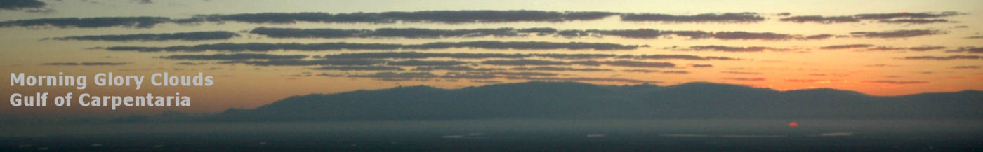

Soaring flight to Groote Eylandt
The Morning Glory of the Gulf of Carpentaria
Douglas Christie and Russell WhiteFirst published AOPA January 1995
General Description
Recent studies have shown that Morning Glory roll cloud formations often extend in length for over 1000 kilometres (see Figure 2).
Despite their ominous appearance, they seldom produce measurable precipitation, but are almost always accompanied by a short-lived, but often intense, wind squall near the surface which may be a potentially serious wind shear hazard for aircraft. Morning Glories propagate on average with speeds of about 40 kilometres per hour, but occasionally are observed to travel at speeds of over 60 kilometres per hour. Morning Glories tend to occur on a daily basis at Burketown over periods ranging from three to seven days in succession.
Solitary Waves
Origin
More than half of all disturbances observed at Burketown belong to the category of northeasterly waves. These disturbances originate during the previous evening in the collision between two opposing intense tropical seabreeze fronts over the highlands of the Cape York Peninsula. Waves of this type propagate at night towards the southwest over the Gulf of Carpentaria, arriving near dawn over Burketown. The cloud formation associated with northeasterly Morning Glory waves dissipates fairly rapidly as the disturbance moves inland into drier air over northern Queensland. Even after the cloud dissolves, however, the disturbance continues to propagate inland, often for distances in excess of two hundred kilometres, as a clear-air wind squall.
The genesis of southerly Morning Glory waves remains obscure. Some of these waves have very large amplitudes and may be accompanied by spectacular roll cloud formations; other southerly waves take the form of relatively minor disturbances with amplitudes of only a few hundred feet. There is clear evidence to show that some southerly disturbances originate over the interior of the Australian continent in the interaction of a mid-latitude cold front with a developing nocturnal radiation inversion. Little is known with certainty about the origin or properties of morning glories which arrive at Burketown from the southeast. Some of these waves appear to be generated by thunderstorms which often develop in the late evening over the region to the northeast and east of Mount Isa.
The genesis and propagation of Morning Glories is controlled by synoptic conditions which turn out to be nearly identical for all types of wave. Thus, northeasterly, southerly and southeasterly waves may occur simultaneously over the southern Gulf region. Favourable conditions for the occurrence of Morning Glory waves at Burketown include a significant pressure ridge over the east coast of the Cape York Peninsula, absence of storm activity over the Burketown region and a well-developed sea-breeze regime over the southeastern Gulf area on the preceding day.
These conditions are enhanced by the presence of an inland heat trough
and an advancing frontal trough system south of the Gulf of Carpentaria.
The presence of an inland heat trough and ridging over the eastern Cape
York Peninsula will almost always guarantee that a northeasterly Morning
Glory will arrive at Burketown on the following morning. It has proven
to be fairly difficult, however, to predict the precise arrival time of
northeasterly Morning Glories over the Burketown area, the size of these
disturbances and whether or not these disturbances will be accompanied
by a spectacular roll cloud formation.
Soaring on the Morning Glory
The art of soaring on the Morning Glory was pioneered in an historic flight by Robert Thompson and Russell White on 13 October, 1989 in a motorised Grob-109 glider. Robert and Russell and other experienced glider pilots have since completed more than a dozen successful flights on Morning Glory waves, some of which have lasted for more than three hours and have covered distances of over three hundred kilometres. These flights have generated considerable interest in the gliding community and it appears that Burketown is set to become a Mecca for gliding enthusiasts from around the world. A photograph of a Morning Glory disturbance which was taken while soaring in the Grob-109 is shown in Figure 3.
Soaring on the Morning Glory at speeds which are comparable with existing world record speeds is one of the most exciting and exhilarating experiences that the gliding world has to offer. A typical flight starts with a motor-assisted take-off at first light from the sealed strip at the Burketown aerodrome. All flights to date have been carried out on northeasterly Morning Glories. In most cases, the Morning Glory is first encountered over the Gulf as a moving mountain of cloud while the aircraft is still at a fairly low altitude. At this point the aircraft is directed along the axis of the wave and the engine is switched off. The glider then ascends very rapidly in the strong updraft along the face of the advancing roll cloud. This is perhaps the most exciting and scenic portion of the flight.
The strong updraft along the leading edge of the wave extends over a broad area ahead of the wave above the top of the cloud and provides useful lift to heights of at least 10000 feet AGL. This means that the flight direction along the axis of the roll cloud can be safely reversed with ease at any time. Flights of more than 300 kilometres along the length of the wave may be possible in some cases, but the pilot must always keep in mind that the wave is eventually going to disappear as it moves inland over very inhospitable terrain with very few possibilities for a safe landing. It is for this reason that we strongly recommend that soaring on the Morning Glory should be restricted in most circumstances to motorised gliders.
Glider pilots should also be aware that the trailing edge of Morning Glory waves harbours potentially dangerous down-draughts which could leave any aircraft which has been unfortunate enough to end up on the wrong side of the wave in a precarious position. Attempts to fly under Morning Glory roll clouds could also lead to disaster and should be avoided. One other potential hazard which glider pilots should steer clear of is the large amplitude disturbance in the form of a localised breaking wave which may appear at the point of intersection between two independent interacting Morning Glories. The point of intersection where these isolated breaking waves occur is often obscured over the Gulf by a developing thunderstorm triggered by the large amplitude of the disturbance at that point.
The 1994 Morning Glory Season
Some of the most spectacular Morning Glory wave disturbances seen in recent years occurred during the months of September and October, 1994. Several successful flights on these waves were made by a number of glider pilots. A particularly spectacular Morning Glory occurred near dawn on the 20th of October. Russell White and co-pilot Karin Jurgenson, who normally pilots the Burketown Pub's Cessna-337, launched in the Grob-109 at first light and almost immediately encountered a strong clear-air Morning Glory wave with strong turbulence. Having radioed a warning not to launch to the other glider pilots, they feathered the prop and headed northwest into the gloom towards a developing rollcloud illuminated by the full moon with just a hint of colour from the rising sun. It was astonishingly beautiful.
By dawn they were over Point Parker on the coast at 6000 feet, with the cloud now well formed ahead and continuing out to sea in the general direction of Gove. A sheer wall of cloud several thousand feet high designated an area of extremely strong lift so a speed run over the next 100 kilometres was deemed essential. This led to ground speeds in excess of 125 knots. The lift was so strong it was impossible to keep the glider from climbing at 400 feet per minute even at speeds close to VNE in the impeccably smooth air during this phase .
As the glider passed the Edward Pellew Group of islands the roll cloud evaporated leaving only some scattered clouds to indicate the position of the wave. With some trepidation, the pilots cautiously picked their way across a large expanse of blue sky towards what appeared to be a developing cumulonimbus in the direction of Groote Eylandt. This proved to be a reforming visible Morning Glory cloud line with cumulus breaking through on top. Soaring along the front of this line at 8000 feet at high speed was spectacular, with cloud tops, accompanied by isolated lenticulars, rising to well over 10000 feet. This particular Morning Glory was by far the largest Morning Glory ever seen from the air at such close quarters.

The flight continued past the southern side of Groote Eylandt to
less than 30 kilometres out from Numbulwah on the western side of the Gulf
with the coast of Maria Island just visible to the south. At this point
the cloud line started to disintegrate again and so the pilots reversed
direction and soared along the wave back to the southern coast of the Gulf
which they crossed in the vicinity of West Island, some 30 kilometres east
of Booroloola. Shortly after, the cloud evaporated as the wave moved inland
and the lift died.
It was time to celebrate. The pilots had established a new long distance record for soaring on the Morning Glory. They had soared a touring glider over 700 kilometres in not much over 4 hours, mostly over water, at an average speed more in keeping with that of a racing glider out for a world record attempt. Karin quite enjoyed her first glider flight.
The unusually large amplitude Morning Glory on the 20th of October was not the only spectacular wave during the 1994 season. On the 29th of October, a Baron departed Normanton after the first wave of a northeasterly Morning Glory went through and experienced a climb rate of 3000 feet per minute along the leading edge of the second wave. As the Baron's usual climb rate is about 1200 to 1500 feet per minute, it would be safe to conclude that the lift along the front of the primary wave in this event could have been as high as 20 knots.
This northeasterly disturbance comprised at least 10 visible roll clouds.
At almost the same time, a set of three southerly Morning Glory waves passed
over the Burketown airstrip at about 30 knots, each perfectly formed and
stretching from horizon to horizon. From the air, a 360 degree turn in
the glider revealed literally dozens of waves in nearly every sector of
the sky as yet another set of Morning Glories arrived over the southern
Gulf region from the southeast. Claude Nowland, a resident of Burketown,
claimed that the Morning Glory display on the morning of October 29 was
one of the most spectacular displays that he has ever seen during his 17
years in Burketown.
Wind Shear and Air Safety
The leading updraft and trailing down-draughts in intense solitary wave
disturbances may exceed 20 knots and the horizontal wind component near
the surface can vary by more than 30 knots during the passage of the wave.
Aircraft which encounter a solitary wave from the front (the structure
of a typical family of solitary waves is shown in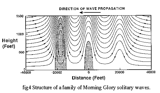 Figure
4) will rise above the intended flight path under the influence of the
leading up-draught and increasing headwinds. The natural reaction of a
pilot at this point is to attempt to return to the normal glide path, but
this action, when combined with the sudden loss of headwind and increasing
downdraughts behind the wave can leave the aircraft perilously close to
ground, well short of the runway threshold. The situation faced by a pilot
may be more complicated when the aircraft encounters more than one solitary
wave while on final approach. In this case, the winds acting on the aircraft
may give the appearance of alternating head and tail wind components, thus
compounding the problem of aircraft control. It seems clear that, given
the choice, pilots should avoid landing or flying through propagating roll
cloud formations like the Morning Glory.
Figure
4) will rise above the intended flight path under the influence of the
leading up-draught and increasing headwinds. The natural reaction of a
pilot at this point is to attempt to return to the normal glide path, but
this action, when combined with the sudden loss of headwind and increasing
downdraughts behind the wave can leave the aircraft perilously close to
ground, well short of the runway threshold. The situation faced by a pilot
may be more complicated when the aircraft encounters more than one solitary
wave while on final approach. In this case, the winds acting on the aircraft
may give the appearance of alternating head and tail wind components, thus
compounding the problem of aircraft control. It seems clear that, given
the choice, pilots should avoid landing or flying through propagating roll
cloud formations like the Morning Glory.
Conclusion
Suggestions for further reading
Christie, D.R. and Muirhead, K.J. 1983. Solitary waves: a hazard
to aircraft operating at low altitudes.
Aust. Met Mag., 31, 97-109. Doviak, R.J. and Christie, D.R. 1989. Thunderstorm-generated solitary waves: a wind shear hazard. J. of Aircraft, 26, 423-43 1.
White, R. 1991. The Morning Glory. Australian Gliding, 40, 34-40.
Christie, D.R. 1992. The morning glory of the Gulf of Carpentaria: a paradigm for non-linear waves in the lower atmosphere. Aust. Met Mag., 41, 21-60.

|

|
home | sitemap | aviation topics
Copyright © 1997-2026 dropbears ![]()